Home / Guides / How to take buses in Korea in English
How to take buses in Korea in English (2026): Naver Map, bus stop boards, T-money
How to take local buses in Korea as a foreigner: Naver Map in English for routes and live arrivals, what Google Maps can and can’t do, reading the bus stop board, paying with T-money, and the 1330 hotline.
Short version: For buses in Korea, try Naver Map: it's one of Korea's most-used map apps, it can be switched to English, and it shows live bus arrivals. Google Maps also does public transport directions here, but still has no turn-by-turn walking or driving navigation. Pay with a transit card such as T-money, not cash: many routes no longer take cash at all. If you get stuck, call 1330.
Last checked: 24 October 2026. Payment rules and Google Maps features in Korea are changing this year and next. I'll update this page when they do.
1. Use Naver Map, set to English
Naver Map is one of Korea's most-used map apps: in early 2026 it had more monthly users than Kakao Map or Google Maps, according to the app-analytics firm Mobile Index. It has an English interface, and the Korea Tourism Organization lists it among its recommended apps for visitors. Naver says its English version shows real-time public transport arrival information.
- Install Naver Map (iOS or Android).
- Switch the app's language to English.
- Search for where you're going, then choose public transport for bus and subway options.
On my own phone (Naver Map in English, October 2026), the stop name, its ID number, route numbers, route endpoints and direction ("… bound") all showed in English. In the morning it also showed live arrivals in English: minutes away ("4min"), stops away ("2 stop(s)"), a "Standby" label, and a crowding label ("Good"). Some route descriptions are literal translations, some map labels stay in Korean, and the same name can be romanised two ways: the stop I checked appeared under two different spellings. If a search doesn't find your stop, try the other spelling, or paste the stop's Korean name (you can copy it from this site) into the search box.
2. Google Maps: directions yes, navigation no
Google Maps in Korea gives public transport directions, which is often enough to find the right bus number. What it still can't do here is turn-by-turn walking or driving navigation.
The Korean government conditionally approved Google's request to use detailed map data in February 2026, but as of late September 2026 navigation still hadn't launched and Google hadn't announced a date. Until it does, use Google for planning and Naver Map on the ground.
3. At the bus stop
- Many bus stops, especially in Seoul, have an electronic board showing which buses are coming and how many minutes away they are.
- The language on these boards varies from place to place. In my experience some show Korean only and some sometimes show English too, so don't rely on the board being in English. Check Naver Map in English as well.
- Drivers sometimes pass a stop if nobody seems to be waiting. Stand where the driver can see you as your bus approaches.
- Tap your card on the reader as you get on.
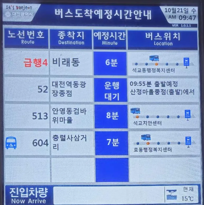
The board in the photo above is from a stop in Daejeon (October 2026). Its column headings are in Korean and English: Route (노선번호), Destination(종착지), Minute (예정시간) andLocation (버스위치). Apart from the route numbers, everything in the rows was in Korean: the destinations, where each bus was, and the times, such as 6분(6 minutes). One row read 운행대기, "waiting to run", with the time it was due to leave the first stop. That's why the route number is the thing to match. Most are plain numbers, but some have a Korean prefix, such as 급행4 (express route 4).
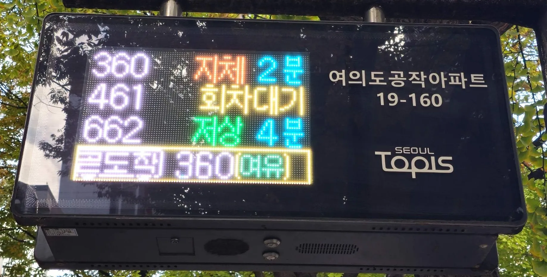
In the photo above (a stop in Yeouido, 26 October 2026), the board's screen shows no English, not even column headings, and while I watched, the bus information never switched to English. The stop's name and number (여의도공작아파트, 19-160) are printed beside the screen. Each row is a route number, then a word and, in most rows, the minutes. Here's what I could pin down:
- 저상 next to the minutes marks a low-floor bus (Seoul city).
- 곧도착 on the bottom line means arriving soon, followed by the route number (Seoul city).
- The word in brackets is how crowded the bus is. Seoul uses three levels:여유 (you can get a seat), 보통 (standing passengers can each hold a handle) and 혼잡 (people standing in the aisle, bodies touching), according to Seoul city.
- 지체 literally means "delay". In two of my photos, route 360 showed 저상 2 minutes in one and 지체 2 minutes in the other. I couldn't find an official explanation of when the board shows it.
- 회차대기 literally means "turnaround wait". I couldn't find an official explanation of this one either.
Reading the stop sign itself
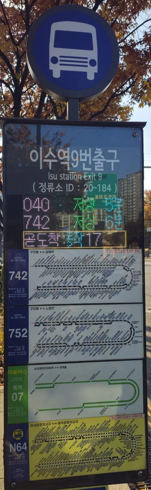
Even when the LED board is Korean only, the printed part of the sign can help. On this one:
- The stop name is in English too: 이수역9번출구 / Isu station Exit 9.
- The stop ID (정류소 ID: 20-184). Seoul stops each have their own five-digit ID (Seoul city). Naver Map in English shows the stop ID number as well, so you can check it against the sign to be sure you're at the right stop.
- One strip per route below the board, with the route number on the left. The stop lists and maps on these strips are mostly in Korean, so use them only to see which routes stop here, then check where they go in Naver Map.
- Village buses (마을버스, the green strip here) are local routes linking neighbourhoods to nearby stops and subway stations (Seoul city). Their numbers usually start with a district name in Korean, like 동작 07 on this sign.
- N before the number, as in N64, means a night bus. The N stands for "Night" (Seoul city).
4. Paying the fare
Use a transit card, not cash. About 180 of Seoul's city bus routes no longer accept cash (as of early 2026), and most of Incheon's city buses went cashless in 2025. A rechargeable card such as T-money is the simple answer. You can buy and top one up at convenience stores, and in Seoul also at subway station information centres (Lines 1–8).
Foreign credit cards can't be tapped on buses yet. Since March 2026, Visa and Mastercard cards issued abroad can be used at new ticket machines in some Seoul subway stations (lines 1–8) to buy tickets and passes, but not on the bus itself. The card company Hana Card says tapping foreign cards directly on Seoul city buses is planned to start in January 2027.
Staying in Seoul for a few days? The Climate Card short-term pass for visitors gives unlimited rides on most Seoul subway lines and Seoul city buses (some lines and routes are excluded). It comes in 1, 2, 3, 5 and 7-day versions.
Tap when you get off, too. In Seoul, tapping your card as you leave the bus is what gives you the transfer discount. You then have 30 minutes to board your next bus or subway (60 minutes between 21:00 and 07:00), and you can transfer up to four times.
5. Seoul's bus colours
| Colour | What it is |
|---|---|
| Blue | Trunk lines: long routes across the city |
| Green | Feeder lines: short routes linking neighbourhoods to subway stations |
| Red | Express routes linking Seoul with nearby cities |
| Yellow | Short loops in central Seoul |
| Green (마을버스) | Village buses: local routes to nearby stops and subway stations |
6. When you're stuck: 1330
The Korea Travel Hotline answers tourist questions in English and several other languages, including help with transport.
- In Korea: dial 02-1330 from a mobile phone.
- From abroad: +82-2-1330.
- Official sources disagree on whether it runs 24 hours or 7am to midnight, so don't count on it late at night.
Using buses to reach my field notes
My field notes are all outside Seoul, and I drive to them, so many of them tell you to check the live bus route in Naver Map rather than giving a route number. The steps above are how to do that.